ACEINNA Inc., which develops inertial based guidance and navigation systems for autonomous vehicles and devices, today announced the commercial availability of OpenARC. The company said its new positioning hardware and software offers easy systems integration.
Andover, Mass.-based ACEINNA said its MEMS-based, open-source, inertial sensing systems enable centimeter-accurate navigation systems. The company said its isolated current sensor product family is based on an AMR technology in a simple, cost-effective, single-chip form factor.
OpenARC is powered by Point One Navigation Inc.'s platform, which is built on satellite navigation, computer vision, and sensor fusion. The San Francisco-based company claimed that its systems outperform other options by tightly coupling the strengths of different sensor modalities and intelligently using proprietary data.
ACIENNA designs OpenARC to improve positioning
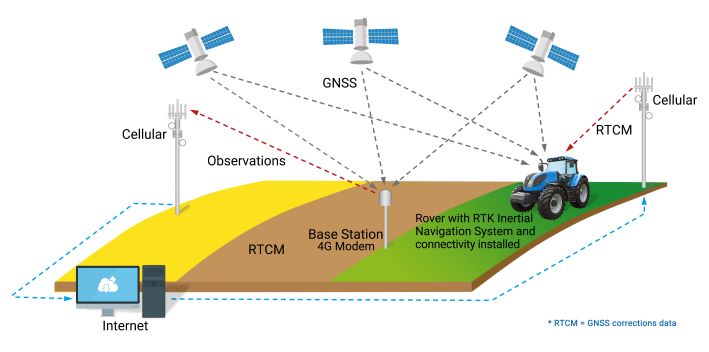
Autonomous vehicles require position accuracy better than 10cm (3.9 in.) to achieve the performance targets and safety goals. Unfortunately, the Global Navigation Satellite System (GNSS) alone falls short, enabling only meter-level position accuracy, even under ideal operating conditions. A navigation system that includes a real-time kinematic (RTK) positioning engine and GNSS corrections delivered from a ground-based network of secure base stations will reliably improve position accuracy to centimeter-level accuracy, according to the companies.
The streamlined OpenARC positioning platform combines Point One’s Polaris GNSS correction service with ACEINNA’s OpenRTK330 hardware and software. OpenRTK is intended for developers of autonomous systems in trucking, precision agriculture, construction, mapping, surveying, and robotics. OpenARC provides precision and confidence in positioning and localization for challenging tasks such as lane keeping, agricultural guidance, and unmanned aerial vehicle (UAV) landing maneuvers.
OpenARC is integrated into the OpenRTK330LI navigation module to provide a secure, vertically integrated, and easy-to-use positioning platform, said ACIENNA. The product offers an easy registration and activation process and is very scalable, supporting single-unit installations to high-volume deployments.
Polaris powers OpenARC
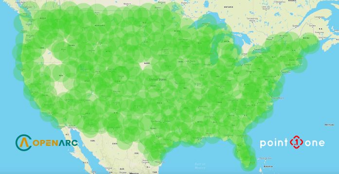
Point One said its proprietary Polaris GNSS cloud correction service was designed for automotive and robotics customers. Polaris delivers station density in cities and suburbs, enabling cold convergence times of under 10 seconds—the fastest of any network solution available, claimed Point One.
Polaris provides continuous position monitoring and tracks all modern satellite constellations for accuracy and confidence. Fully owned by Point One, the Polaris network uses the latest in base-station technology including advanced anti-jamming, interference mitigation, security, and integrity monitoring.
In addition, Polaris' cloud-based correction architecture allows for GNSS corrections in RTK or State Space Representation (SSR) configuration. Its open-source interfaces are compatible with receivers and chipsets from leading providers. The service is also compatible with any NTRIP/RTCM3-compliant receiver, said Point One.
“We are excited to launch OpenArc, the most reliable, turnkey and affordable precise positioning solution on the market,” stated Dr. Yang Zhao, chairman and CEO of ACEINNA. “OpenARC integrates high-performance inertial navigation hardware and algorithms with Point One’s unique technology. ... This enables our customers to optimize their development costs by leveraging our combined expertise, which we now bring to many industries and applications together through our partnership.”
“Point One’s highly adaptable Polaris network is now fully deployed coast to coast, supporting many precise positioning and autonomous applications,” said Aaron Nathan, co-founder and CEO of Point One. “OpenARC delivers a precise yet affordable corrections-based solution that is easy to use.”
Article topics
Email Sign Up

Related ACIENNA News


Related Companies