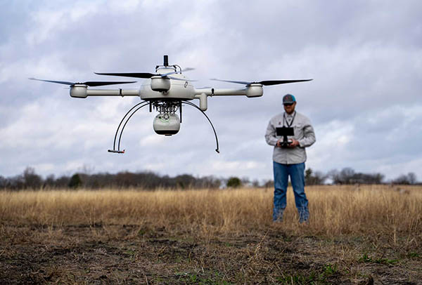
Monitoring development projects from start to finish is key to ensuring the accuracy and success of the overall design plan, according to Adams Surveying LLC. In its “Down to Earth, Above the Dirt” video series, the company explains how its drone surveying services have helped keep its customers on time and within budget. Adams Surveying uses drone-based lidar from Microdrones GmbH to quickly gather data for project analysis and volume measurements.
“Down to Earth” is a documentary-style series that shows how real surveyors collect data and turn it into deliverables despite challenging conditions, hidden dangers, and inclement weather.
Richardson, Texas-based Adams Surveying provides licensed, professional land-surveying services throughout the state of Texas. The veteran-owned small business said it serves a range of clients and projects with expert staff and equipment including robotic total stations, Global Navigation Satellite System (GNSS), and state-of-the-art software. Adams Surveying also provides realty scanning using drone technology.
Microdrones helps verify pre-development
In the first episode of the series, Josh Adams, a surveyor in training (SIT) and small unmanned aerial system (sUAS) pilot for Adams Surveying, explained how the company uses drones for site verification.
“We’re using the drone to verify the roads, pads, and lots,” he said. “We can check the elevations to see how the contractors did versus the engineering plans, to verify that everything was built the way they wanted it to be.”
Adam Gribben, a survey technician and sUAS pilot, assists Josh with the planning and flight missions. Their first project is Spradley Farms, an 800-acre undeveloped site where the team will perform a pre-development flight to provide the necessary data for the customer, Graham Associates Inc., to create their engineering plans.
“The way the Microdrones lidar product help us meet our goals is when we come across open fields where photogrammetry is not going to be able to cut through the canopy or tall grass,” Gribben said.
Founded in 2001, Microdrones has offices in Siegen, Germany, and Rome, N.Y. It delivers industrial survey equipment with a fully integrated geospatial workflow that transforms data collected in the field into survey-grade data.
The company said its mdInfinity data-processing platform enables this transformation of collected data into actionable deliverables and their visualization. Microdrones offers its services through a drones-as-a-service or robotics-as-a-service (RaaS) business model.
Adams Surveying describes projects in 'Down to Earth'
In the second “Down to Earth” episode, Adams Surveying team went to the Karis project in Crowley, Texas, a 900-acre project that’s already under way, to assess progress and calculate dirt levels. The owner of Adams Surveying, Phillip Adams, a registered professional land surveyor (RPLS), joined the team.
“Deploying a system from Microdrones over the site really provides us a quick picture of what’s going on,” he said. “Using the tools available to us, we can provide survey-grade accuracy to the data we’re providing the client.”
The episode also introduced Scott Koehler, a project manager at Graham Associates, who explained how the data is very useful.
“Using the drone services from Adams Surveying allows us to collect the data in the field a lot faster than traditional methods,” he said. “The purpose of the most recent flight was to take a snapshot of where the dirt contractor left the site. You can see how all the pads are created, the side yard swales are cut properly, and that the roads are all much lower than the pads by design.”
The series concluded with Episode 3, in which Gribben processed and visualized the data from both projects to create the final deliverables for Graham Associates. “You’ve got your volumes of dirt measured and you want to know how the project is progressing,” said Gribben. “They say a picture is worth 1,000 words. Well, add the picture plus a couple billion lidar points, and it’s worth even more. Just that resolution and data you can’t really get without drone lidar.”
Article topics
Email Sign Up

Related Surveying News