Autonomous underwater vehicles are not just for pure scientific research, resource exploration, or infrastructure maintenance. They can also detect and monitor more immediate threats to sea life and human health. An expedition led by University of California San Diego’s Scripps Institution of Oceanography recently mapped more than 36,000 acres of seafloor.
Researchers studied an area between Santa Catalina Island and the Los Angeles coast in a region previously found to contain high levels of the toxic chemical DDT. The survey on Research Vessel (R/V) Sally Ride identified more than 27,000 targets with high confidence to be classified as a barrel, as well as more than 100,000 total debris objects on the seafloor.
“Unfortunately, the basin offshore Los Angeles had been a dumping ground for industrial waste for several decades, beginning in the 1930s. We found an extensive debris field in the wide area survey,” stated Eric Terrill, chief scientist of the expedition and director of the Marine Physical Laboratory at Scripps Institution of Oceanography. “Now that we’ve mapped this area at very high resolution, we are hopeful the data will inform the development of strategies to address potential impacts from the dumping.”
AUVs worked in tandem
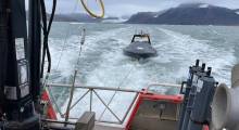
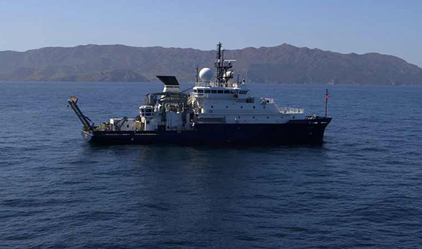
The expedition included a team of 31 scientists, engineers, and crew conducting 24-hour, around-the-clock operations to deploy two AUVs used for the expedition from R/V Sally Ride. The research vessel is one of the most technologically advanced vessels in the U.S. Academic Research Fleet, and is owned by the Office of Naval Research and operated by Scripps on behalf of the U.S. research community.
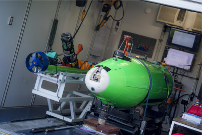
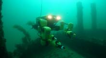
The search entailed work at depths up to 900 meters (3,000 ft.), in what is considered a semi-abyssal, steep seafloor between Catalina and Los Angeles. The two AUVs were deployed to work in tandem to map the seabed at a high resolution. The REMUS 6000 is capable of working up to depths of 6,000 m (19,600 ft.), and Bluefin is capable of depths up to 1,500 m (4,900 ft.).
Pocasset, Mass.-based Hydroid Inc., whose technology is based on research at the Woods Hole Oceanographic Institution and which was acquired by Huntington Ingalls Industries last year, makes the REMUS underwater robot. Fairfax, Va.-based General Dynamics Mission Systems makes the Bluefin AUV, which it acquired with Bluefin Robotics in 2016.
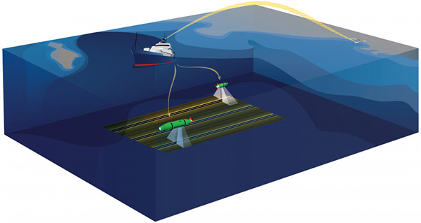
The robots adjust to changes in the topography flying at a constant 20 m (65 ft.) above the seafloor, using high-frequency, side-scan sonar to send signals 150 m (490 ft.) on each side of the vehicle. The continuous echolocation of these signals reflecting from the seafloor creates images of the bottom and the objects resting there.
Scanning the seabed at a rate of 0.75 square kilometers per hour – roughly the size of 140 football fields – the sonar data can be used to detect objects, characterize seafloor habitat, or map hazards. Sonar settings for this expedition were tuned to detect objects as small as a coffee cup.
The ability to operate in deep waters for long duration and survey large areas at very high resolution is what enabled a wide area survey of this magnitude. Underwater acoustics were also used to broadcast GPS signals from the research vessel to the AUVs so that they could be tracked with high precision through each deployment.
Topside, the science team would recharge the instruments, and offload sonar imagery to analyze data. More than 100 gigabytes of sonar data were captured during the expedition.
Expedition finds toxins
The expedition, which ran from March 10 to 24, was developed with NOAA’s Office of Marine and Aviation Operations and the National Oceanographic Partnership Program. The project, part of ongoing collaboration with NOAA’s Uncrewed Systems Operations Center, tested autonomous underwater vehicle (AUV) technology to map the seafloor. As marine robotics continues to advance, NOAA is working with Scripps to transition ocean robotics from research to operational uses.
In 2011 and 2013, UC Santa Barbara professor David Valentine discovered concentrated accumulations of DDT in the sediments in the same region and visually confirmed 60 barrels on the seafloor. Scientists are also finding high levels of DDT in marine mammals including dolphins and sea lions, with exposure to PCBs and DDT linked to the development of cancer in sea lions.
Reporting on this issue by the Los Angeles Times noted that shipping logs from a disposal company supporting Montrose Chemical Corp., a DDT-producing company, show that 2,000 barrels of DDT-laced sludge could have been dumped each month from 1947 to 1961 into a designated dumpsite.
In addition to Montrose, logs from other entities show that many other industrial companies in Southern California used this basin as a dumping ground until 1972, when the Marine Protection, Research, and Sanctuaries Act, also known as the Ocean Dumping Act, was enacted.
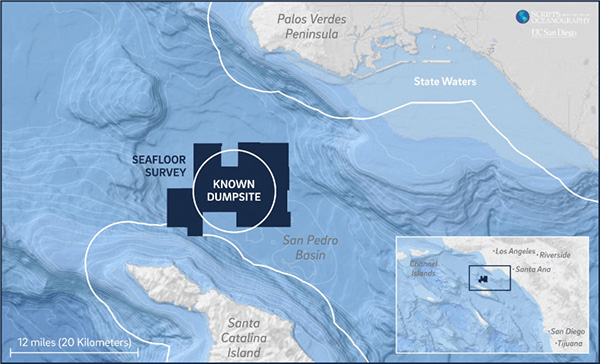
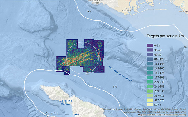
Barrels and targets of interest were found in nearly all areas of the 36,000 acres surveyed and extended beyond dumpsite limits, which is roughly 12 miles offshore Los Angeles, and eight miles from Catalina Island. The 25,000 targets identified with confidence to be barrels had stronger brightness in their acoustic signal and distinct geometry in the shape of the image.
The other objects identified also showed these signals, however, not as bright or distinct, which could be due to how deep they were deposited in the sediments, or deterioration of the material. There were also patterns that indicate how the barrels were dumped.
“There are several distinct track-line patterns in the surveyed area, suggesting that the dumping was repeatedly done from an underway platform such as a moving ship or barge. Some of those lines are as long as 11 miles and approach state waters,” said Terrill. “While our mapping sonars cannot measure the contents inside the barrels, the target locations are consistent with the previously identified dumpsite and extend much further than we expected.”
Studying the data
Since the expedition, researchers have been analyzing the acoustic imaging data of this complex site. Typically, manually counting the targets is the approach taken with side-scan sonar processing, but this approach was not feasible given the size and extent of the survey area.
An automated process was used, perhaps the first time automated approaches have been done at this scale, said Terrill. The 60 barrels confirmed by Valentine in 2011 and 2013 served as a reference point for validating detection algorithms that were developed to find barrels.
“The data from the Valentine expedition were used to ground-truth our algorithms,” said Sophia Merrifield, a researcher at Scripps who has been leading the data analytics after R/V Sally Ride returned to shore. “Location, size, and acoustic brightness are tracked for each target detected and used to characterize patterns and densities of the debris field.”
Terrill’s team is now working to finalize the release of the sonar data, which it hopes will serve as a catalyst for an action plan and additional research endeavors to understand environmental impacts.
There is a lot to be understood towards how DDT is impacting our environment and marine food webs, according to Lihini Aluwihare, Scripps chemical oceanographer and professor of geosciences. In 2015 she co-authored a study that found high abundance of DDT and other man-made chemicals in the blubber of bottlenose dolphins that died of natural causes.
“The uniquely high body burden of DDT in top predators feeding in Southern California waters has been known for some time,” said Aluwihare, who was not part of the survey expedition. “The extent of the dumping ground helps to explain some of these previous observations.”
“These results also raise questions about the continued exposure and potential impacts on marine mammal health, especially in light of how DDT has been shown to have multi-generational impacts in humans,” she added. “How this vast quantity of DDT in sediments has been transformed by seafloor communities over time, and the pathways by which DDT and its degraded products enter the water column food web are questions that remain to be explored.”
About Scripps Oceanography
Scripps Institution of Oceanography at the University of California, San Diego, is a center for global earth science research and education. In its second century of discovery, Scripps scientists work to understand and protect the planet, and investigate our oceans, Earth, and atmosphere to find solutions to environmental challenges. Scripps offers undergraduate, master’s and doctoral programs. The institution also operates a fleet of four oceanographic research vessels and is home to Birch Aquarium at Scripps, a public exploration center that welcomes 500,000 visitors each year.
Article topics
Email Sign Up

Related Underwater News