Between aerial drones and ground robots, autonomous data collection is getting easier for a variety of industries. DroneDeploy Inc. today announced new offerings during its sixth annual DroneDeploy Conference.
“At DroneDeploy, we see a future where intelligent, autonomous, ground and aerial robotics work alongside us to amplify human potential,” said the San Francisco-based company. “They will automate laborious tasks, keep us out of harm’s way, and help us make better business decisions every day.”
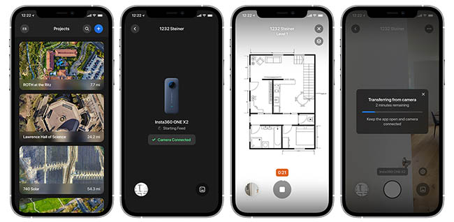
DroneDeploy announced its updated Walkthrough App, which enables any data captured by a 360 camera to be uploaded directly from a user's mobile phone and read and shared shortly thereafter. It also introduced Levels, an improved workflow for interior data capture across multi-level buildings for architecture, engineering, and construction (AEC) projects.
The company also announced the beta of Ground Robotics Automation, which is similar to its flight-planning capabilities for drones and allows for prescheduled missions to inspect fields, construction sites, or other assets.
Need for data grows
Drone usage is growing particularly quickly in the energy industry, said DroneDeploy. Flights grew by 38%, and the number of users increased 10% in the second quarter of 2021, with 51% growth in the number of fligths and 9% increase in uses from Q3 2020, it said. However, the total growth since 2019 has been more significant, with triple the number of flights and 54% more users from Q3 2019, claimed DroneDeploy.
“During the warm summer months in the northern hemisphere and the start of spring in the southern hemisphere, commercial drone usage remained fairly steady from Q2 to Q3,” said the company. The third quarter of 2021 saw a 61% increase in flights and a 47% increase in users from the same quarter last year. Again, flights were up 229% and users grew by 154% from Q3 2019, according to DroneDeploy.
“While we expect a slight downturn in Q4 in the northern hemisphere, we expect to see a slight increase in APAC [the Asia-Pacific region] as it hits summer season,” the company said. DroneDeploy acquired Rocos in August.
“We believe that all of the media and 3D data you capture on your projects, fields, and assets should be organized in one, simple, measurable source of truth,” stated DroneDeploy. “It should be laid out logically and geospatially, as you’d expect to find it in the physical world. Your team should have instant, secure access from wherever they are. Whenever they need it.”
Walkthrough App now available
Last year, DroneDeploy released the first version of its 360 Walkthrough product. The new Walkthrough for iOS app can help users capture 360-degree walkthroughs with a couple of taps, said the company.
Users can download DroneDeploy Walkthrough from the iOS app store, select a project, connect a camera, and hit record. The app can automatically pick settings to retain detail while reducing file size by nearly 10 times, DroneDeploy said. It automatically uploads and processes the data.
“DroneDeploy Walkthrough makes the camera in your pocket ready for any project, a powerful tool to capture any asset or construction project from any vantage point,” the company said. “Field and project engineers can level up their site walks, capturing conditions for client updates, documentation, and planning. Operation leads on an energy site can digitally document assets to facilitate faster and more efficient remote inspections.”
All users can capture data with the new Walkthrough app, but they must have Enterprise Projects and a 360 Walkthrough subscription to process uploads.
DroneDeploy offers Levels and angles
With Levels, customers can filter 360 data and associated floor plans faster by each floor, project phase, and time period, without the need for a drone map or 3D model, said DroneDeploy.
In addition, DroneDeploy announced Floor Plan View, which organizes data by level. Users can compare installation progress across different dates in the same location within a building. Similarly, deviations from plans, incorrect installations, or safety hazards can now be marked as issues and pushed to project management tools such as Procore or Autodesk BIM 360. Assigned project members can click a link back into DroneDeploy for the visual context to assist with issue resolution. Floor Plan View is available on Enterprise Projects with 360 Walkthrough.
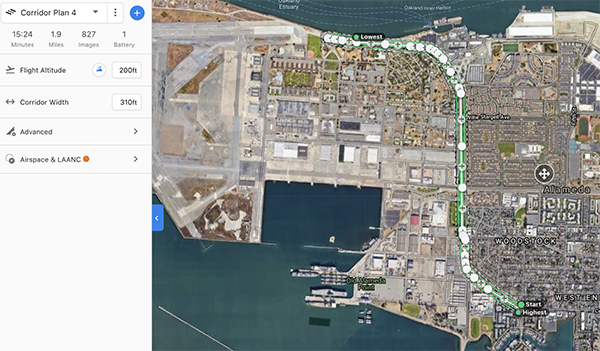
Corridor Flight is intended to efficiently map roads, railways, canals, pipelines, or other linear areas. One customer, Chasco Constructors, has already mapped over 1,500 miles of road, bridges, and utilities, said DroneDeploy. Corridor Flight is available on all paid subscriptions.
DroneDeploy said its systems are now compatible with more sensors and has added support for the Matrice RTK drone.
Enterprise subscribers can also processs radiometric data captured with the H20T, Mavic 2 Enterprise Advanced, and XTS sensors. All customers can customize the gimbal angle, which is helpful for roof or solar panel inspections, said DroneDeploy. Radiometric processing support is available for Enterprise Subscriptions. Custom gimbal angle is available to all users.
Two ways to share data
The ability to share data with clients and stakeholders is just as important to many users as capturing and measuring that data, said DroneDeploy.
“If you are in construction, you can now upload your mobile photos from your Walkthrough into DroneDeploy,” it said. “They will be tagged to the project’s location so you can quickly alert team members of issues on site – bringing all of your site reality into one solution.”
“If you’re in agriculture, you can take photos with your mobile device while scouting a field, then upload them with the map to better document any issues affecting crop health,” it said. Photo Inspections are available to Business and Enterprise customers.
The company has added two ways to share data. First, users can now share a view-only link from a particular day providing access to content including annotations, measurements, isue markers, and walkthroughs. This capability is available on all paid subscriptions, and it is viewable on the user interface with no sign up required.
“Second, for long-running jobs, customers on our project-based packages can share a single link that provides view-only access to the entire project, media, and history,” said DroneDeploy. “One link that always defaults to the latest data automatically. It’s perfect for integrating into a project management platform like Procore or Autodesk Construction Cloud via our Embedded app. This capability is available on Enterprise Project subscriptions.”
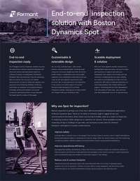
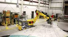
Ground Robotics Automation
“Regular inspections are vital to keeping construction projects on schedule, but capturing this data is labor-intensive. Traditionally, employees had to walk around job sites with handheld cameras or scanners,” said DroneDeploy. “Manually inspecting solar farms can take months, with employees traveling to remote locations and walking for miles in high temperatures to check the condition of assets.”
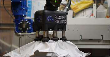
DroneDeploy said its Ground Robotics system enables users to send ground robots such as Boston Dynamics' Spot on autonomous inspection missions. They can be equipped with 360 cameras, gas sensors, or thermal cameras, which can upload data to DroneDeploy for a 360 Walkthrough.
Users can then tag and annotate issues such as loose wiring, broken pipes, or debris and assign them to employees, reducing rework, said the company. Ground Robotics is a limited beta for Enterprise customers only, said the company.
Article topics
Email Sign Up
Related Inspection News


Related Companies
Related Resources