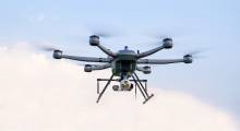
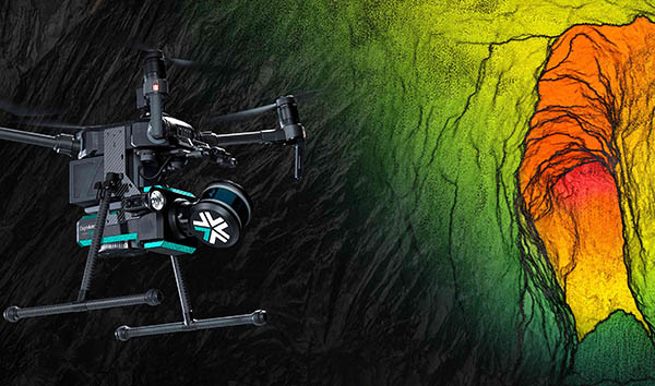
One set of robotics applications that benefits the most from increasing levels of autonomy is drone inspections. Exyn Technologies has been developing autonomous aerial drones for complex, GPS-denied environments. The Philadelphia-based company is a spin-out of the University of Pennsylvania's GRASP Laboratory and said it suppports the mining, logistics, and construction industries with its “full-stack solution.”
In March, Exyn Technologies announced that it had expanded its strategic partnerhsip with Sandvik Mining and Rock Solutions to integrate Exyn's data with Sandvik's OptiMine analytics and process optimization suite. The partners said mining companies can use the ExynAero drone with ExynAI-powered onboard mapping technology to gather and process data that the OptiMine Mine Visualizer can use for analysis and optimization of production.
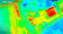
Last month, Exyn Technologies said it has achieved Level 4A autonomy, the highest documented level of aerial autonomy to date. The company said its drones can now freely explore highly complex spaces without falling back to human operators. They can do this at 2+ m/sec. (4.47 mph)—double the flight speed and collecting more data of previous levels, claimed Exyn. It said its drones can cover 16 million cubic meters (565 million cubic feet), the equivalent of nine football stadiums.
This month, the Association for Unmanned Vehicle Systems International (AUVSI) named Exyn a finalist in the Technology Category of its XCELLENCE Awards for its innovation.
Robotics 24/7 spoke with Ben Williams, chief operating officer of Exyn Technologies, about his company's approach to drone autonomy. He is a former naval officer and worked on energy technology at Lockheed Martin. After working at a few automation startups, once of which AT&T acquired, Williams joined Exyn two years ago, just as it began transitioning from pure research to commercialization.
Drones plus AI, minus pilots
Can you briefly describe Exyn's approach to autonomy and how it differs from that of other drone inspection providers?
Williams: We believe that industries need to find a way to digitize their worlds so they can apply machine learning and artificial intelligence to data. Then they can apply that big data to informed decisions back in the real world.
Our core mapping technology is more accurate, has less drift, and is able to synthesize multimodal models overlaid with visuals for gas sensing, radiation, and temperature. We haven't seen anyone be able to put these together in 4D models as we have. To be relevant for commercial operations, you can't send data to the cloud and then wait until the next day. Businesses need to make real decisions—we talk about “same-shift decisioning.”
Exyn's big differentiator on the data side is the data processing, algorithms, and post-processing in real time. We're able to support informed decisions right in the field or right after a survey.
On the autonomy side, most drones need a pilot, inherently tethering a person to one to three drones. We've been able to demonstrate with a pilot out of the loop, with one operator to 10,000 drones. By making remote actuation autonomous and ubiquitous, enterprises can collect drone data every day, every hour, without having to hire thousands of drone pilots.
Exyn's systems are robust to changes in the environment, so you don't need to remap the route every time you send a drone out. For example, a rail line or farm is a great entry-level use case for GPS-driven “lawnmower-pattern” operations, but how do I tackle ground-level information not accessible by GPS-driven systems?
The other half of our autonomy system is that it's infrastructureless and self-contained—we don't depend on external systems. We can navigate 6 to 8 in. away from an object and collect really accurate point-clouds for structural models. It's hard to get that close with GPS or lidar, and it gives us access to indoor and underground infrastructure.
Last fall, the company announced the ExynAero system—can you give some examples of how customers are benefiting from it?
Williams: We've been growing really rapidly in the underground space. Since that time, we've seen dozens of opportunities in other mines. Previous skeptics see Exyn's systems and want to buy. We've seen a ton of growth. We've also seen a lot of adoption by governments.
The next areas of growth for autonomous drones are industrial and commercial spaces. Operators are looking for ways to get more information about facilities, structures, and infrastructure. A lot of industries already have fixed cameras, so they use a roaming sensor suite—which is what an autonomous robot or drone is—to paint a complete operational picture rather than extrapolate.
Exyn partners with Sandvik
How much does Exyn process the data it gathers before passing it on to Sandvik OptiMine Visualizer or other systems?
Williams: Sandvik is the Caterpillar of the underground mining space. When you combine georeference data and autonomy, it's a key linkage between capturing mining data and using it. Before, you'd have to go in and manipulate each point cloud to fit a gap in a map.
Now, a user can hit a button on a tablet, and it's automatically georeferenced. You can manage dozens or hundreds of systems in parallel.
How did the collaboration between Exyn and Sandvik begin? Do you anticipate making more such partnerships?
Williams: We got introduced to them by some early customers who were willing to vouch for us, and we did some demonstrations. They felt confident in our ability to perform and had seen the beginning stages of autonomous drones.
We are looking at other service-based, technology partners, as well as in the government and construction space. We don't think we can tackle every element in different ecosystems. We want to find high-capability partners.
What did you learn in the demonstration with Sandvik and gold exploration company Rupert Resources?
Williams: Our first systems that got deployed were rough around the edges. The core technology worked, but we didn't have a sense of how people would use them. With Rupert and with precious metals and other early partners, we watched how users used our sytsems.
Some parts weren't that intuitive. In some cases, things we thought would be a problem were not, especially around the user interface.
With Rupert, there was less to learn about the basics of mapping. Once they got over, “This is great,” then five minutes later, it was, “You know, it would be nice to….”
What elements of your respective technologies still need to be integrated? What do you mean by “fully autonomous mining operations?”
Williams: You're seeing much faster progress in true autonomy, completely hands-off operations, in mining than in any other application. Sandvik doesn't have full autonomy, since most of drones are remotely operated, but getting to no people on the ground is one of the big gaps to be filled. Survey teams are often in the most dangerous areas today.
As the rate of learning goes up, we'll get to more hybrid operations, and then we can remove the operators from the field more quickly. The hardest element of that paradigm shift is getting comfortable enough to do that. It's also one of the biggest challenges in autonomous driving. Removing people will be easier to do in mining.
Growing use cases
What technologies does the drone industry still need to work on?
Williams: Both we and competitors need more flexibility in our systems to be able to tackle more difficult environments. There needs to be integration, not just with quadrotors, but also a greater variety of drones. We'll see more specialized drones, and in the non-DJI world, we'll see a lot of different architectures, not just in software, but also in physicial structure.
We're hardware-agnostic, and we want to get our system flexible enough to work on swarms and ground robots as well as aerial drones.
For example, our ExynPak handheld combines elements of aerial and ground-based sensing in mining environments. It provides a shared frame of reference for true collaborative autonomy.
What is the most common question that you get from mining operations?
Williams: This has changed rapidly over the past six to eight months. They've been burned before by people claiming full autonomy, so last year, we got asked, “Is it really autonomous? Can it really fly?” It took a while to convince them with demonstrations.
Then it gets to “What does it mean?” We get from “Does this thing work?” to “What are the impacts?”—what are your problems in the mine? The most common questions now revolve around acccuracy, what environments the technology can work in.
We get asked specific questions about the environment of each mine. Every mine has different structures, narrow areas, temperatures, and humidity. Operators now trust the technology generally but wonder if it will work specifically.
Future drone challenges
Exyn Technologies has partnered with the University of Pennsylvania's Team PLUTO for the DARPA Subterranean (SubT) challenge. What do you anticipate for its final challenge in September?
Williams: The DARPA Sub-T Challenge has been going for two and a half years. During that time, the industry has matured rapidly, so you're finding areas where people are pulling ahead of the challenge.
[Program Manager] Tim Chung is clever at putting in traps and tricks beyond just building a textbook environment. That's where this challenge is still fascinating—there's a difference between an ideal environment and “What will they throw at us?”
I'm most looking forward to how the teams try to figure out how they're going to identify things that will the challenge the sytems, both from a schadenfreude way and how it could help inform our development.
What developments in drone exploration or data management do you hope to see this year?
Williams: For this year, we're really doubling down on our core markets of mining and government, where we see a lot of growth and hundreds of use cases. We've delivered as many systems in the past five months as in the entire rest of the company's history.
A year ago, we had tackled the core autonomy and data collection but had not yet tackled data linkages—what happens once a drone has completed its flight. It took time to work on both ends—the technology and the user interface. Sometimes, we cut out data to give users what they want when they want it.
Now that customers have had Exyn's systems for 12 to 18 months, it's more about autonomous systems getting the data and moving on. As remote actuation over 5G networks becomes available, you'll see more and more tasking from anywhere.
When we've arrived as a utility for industry at large, people will get used to it. That will be a critical transition point as distributed autonomy becomes ubiquitous, and you stop noticing it. That's counterintiutively where the industry needs to get to.
About the Author
Follow Robotics 24/7 on Linkedin
Article topics
Email Sign Up
Related Drones News