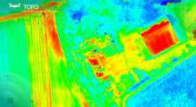
Aerial drone surveys depend on technologies including lidar mapping. mdGroup today announced that it has acquired GeoCue Group Inc. from its founders for an undisclosed amount. mdGroup said the acquisition will strengthen its leadership as a provider of high-end technologies and marks another milestone in its strategy to becoming a “one-stop shop” for drone suyrveying.
“With this acquisition, we are positioned to respond to increasing demand for drone-enabled precision deliverables,” said Vivien HeriardDubreuil, CEO of mdGroup. “This includes classified and colorized point clouds, volume calculation, and contour maps.”
Alpharetta, Ga.-based mdGroup said it uses aerial data to make digital twins for industrial applications. The group's portfolio businesses include Siegen, Germany-based Microdrones GmbH.
Microdrones, which has an office in Rome, N.Y., said it delivers industrial-grade inspection equipment with a fully integrated geospatial workflow. The mdInfinity platform transforms data collected in the field into valuable high-quality, survey-grade data, said the company.
GeoCue joins mdGroup's drone group
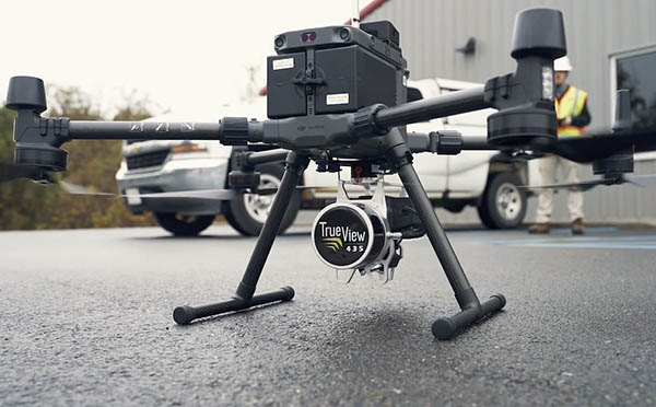
Madison, Ala.-based GeoCue Group offers software, hardware, training, support, and consulting services for high-accuracy lidar and drone mapping. It designs, develops, and manufactures its products in Triana, Ala.
GeoCue said it serves the U.S. mapping, surveying, and engineering industry through its TrueView line of drone imaging sensors and TrueView EVO/LP360 lidar data-processing software. The company added that its technology can help civil engineering and surveying professionals achieve successful data collection, processing, and management.
With GeoCue and Microdrones, mdGroup said it now addresses the full spectrum of professional surveyor needs for drone-enabled data collection and processing tools.
“Both companies will continue to serve customers as they have come to trust and expect,” said Frank Darmayan, chief operating officer of mdGroup. “They can choose Microdrones' fully integrated survey equipment and the mdInfinity cloud data processing platform or GeoCue lidar payloads and EVO/LP360 data processing desktop software.”
mdGroup consolidates aerial lidar offerings
In the near term, the acquisition of GeoCue will not yield any visible change for GeoCue or Microdrones customers. However, mdGroup said it expects significant benefits from the acquisition for both companies.
The deal “dramatically enriches” GeoCue and Microdrones' collective expertise in aerial lidar, consolidates mdGroup’s presence in the U.S. market, and opens the door to the European market for GeoCue products, said the company.
“This further establishes mdGroup as the go-to provider of industrial-grade, high-quality, and Western-made aerial surveying equipment and software,” claimed Francois Gerner, chief financial officer of mdGroup. “In the medium to long term, mdGroup expects customers of both companies to benefit from the outcome of GeoCue and Microdrones' collaboration in the technical field.”
Article topics
Email Sign Up

Related Drones News