GeoCue
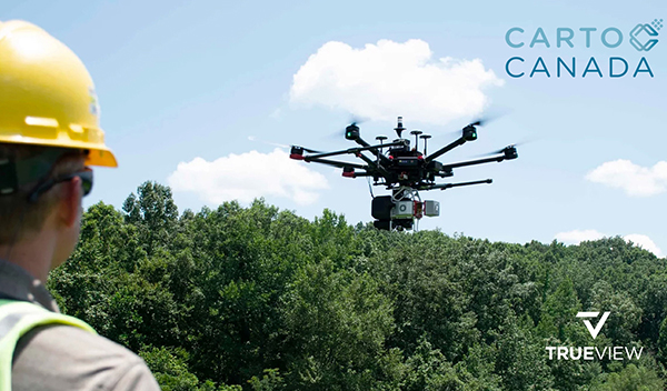
CartoCanada is now distributing GeoCue's TrueView 3D imaging systems and software.
Get news, papers, media and research delivered. Sign up for our free newsletters.
Stay up-to-date with news and resources you need to do your job. Research industry trends, compare companies and get weekly market intelligence with Robotics 24/7.

GeoCue
CartoCanada is now distributing GeoCue's TrueView 3D imaging systems and software.
GeoCue Group Inc. today announced that CartoCanada Inc. is the newest distributor of its drone lidar mapping equipment and LP360 processing software in Canada. CartoCanada is a geospatial technology supplier and consulting company serving surveying, agriculture, engineering, forestry, mining, and construction professionals.
“We think we’ve found an exceptional distributor to introduce Geocue to the Canadian market,” said GeoCue sales manager Aaron Beach, who brokered the partnership. “CartoCanada has the right mix of people and expertise to deliver top-notch sales, training, and support to their customers.”
Madison, Ala.-based GeoCue offers software, hardware, training, support and consulting services for high-accuracy lidar and drone mapping. The company said it helps civil engineering and surveying professionals successfully collect, process, and manage data.
With its TrueView 3D imaging sensors and EVO/LP360 point-cloud data-processing software, GeoCue claimed that it is a leader in lidar mapping processing in North America.
“After investigating several solutions on the market, we decided that GeoCue provided a combination of innovative hardware, intuitive software workflows, and most important a responsive technical support, training, and service department,” stated Richard Andrews, president and CEO of CartoCanada.
GeoCue's TrueView sensors are now available from CartoCanada. The imaging system offers lidar and photogrammetry tools integrated in lightweight drone payloads. The companies said TrueView enables fast, easily automated generation of true 3D colorized point clouds, oblique imagery, and ortho photos from a single drone flight.
CartoCanada is also authorized to sell the LP360 package. The advanced desktop software can easily extract lidar information and generate deliverables in an intuitive GIS environment, said GeoCue.
“Software in the lidar world is critical to the process of managing expectations," Andrews said. "LP360 allows customers a unique pricing model, intuitive, simple workflow to turn your point-cloud data to actionable data for all stakeholders.”
“Our customers are surveyors, engineers, and mapping professionals," said Andrews. "Their ability to complete jobs on time, on budget, and safely is critical to their ROI [return on investment]. Meeting our customer’s ROI expectations is what CartoCanada strives for, and GeoCue will facilitate that for our partners.”
Calgary, Alberta-based CartoCanada offers a range of aerial mapping drones and surveying equipment. It also offers training and support across Canada. The company's systems include include mapping and inspection drones and remotely piloted aircraft systems (RPAS), mobile lidar, and GNSS antennas.
More than a supplier, CartoCanada said it consults with its clients to ensure they get the best geospatial equipment for their needs, helping them increase their project’s productivity, safety, and accuracy of deliverables.
CartoCanada said its team thoroughly researches prospective partners to ensure their technologies are tested, supported, and, most importantly, available when customers are ready to implement. It said this focus provides "a superior level of technical support, knowledge, and service."
“We believe that GeoCue will bring a unique experience to our Canadian clients from what other solutions provide," added Andrews. "Our teams are enthusiastic, smart, and innovative, which translates into a superior customer experience. We welcome the opportunity to work with GeoCue and bring this solution to Canada.”
Canadian Channel Manager Matt Teppler is joined by Karl Canning from CartoCanada on a trip to scan the 'Big Rock', just west of the Town of Okotoks, Alberta Canada.
Enjoyed this article? Add Robotics 24/7 as a preferred source in Google Search.
Edge computing gives AI agents the processing power to turn instructions into…
Daimon-TWM world model debuts for the public
Platform helps robots adapt to complex tasks
Look beyond the headlines for the latest in humanoid robots