GeoCue
TPI and GeoCue celebrate partnership to provide lidar drones and surveying software in Poland.
Get news, papers, media and research delivered. Sign up for our free newsletters.
Stay up-to-date with news and resources you need to do your job. Research industry trends, compare companies and get weekly market intelligence with Robotics 24/7.
GeoCue
TPI and GeoCue celebrate partnership to provide lidar drones and surveying software in Poland.
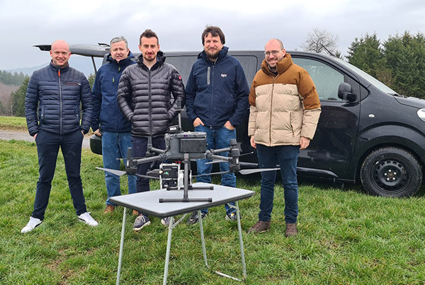
GeoCue Group Inc. has announced that TPI, which claims to be the largest supplier of geospatial equipment in Poland, has officially joined its global distribution network. The companies said the partnership will enable them to expand their reach and provide cutting-edge geospatial systems to customers in Poland and beyond.
"We are excited about this new partnership and look forward to growing the drone surveying equipment market," stated Marcin Jaloszynski, uncrewed aerial vehicle (UAV) product manager at TPI.
TPI supplies measurement systems for surveying, construction, industry, and precision agriculture in Central and Western Europe. The company's TPI Netpro network consists of 141 stations adopted for the geodetic national list.
TPI is a supplier of Topcon, Faro, Geoslam, DJI Enterprise, AgEagle, Quantum-Systems, Sokkia, and Nivel System products for 3D scanning, documentation, and geodesy. It has offices in Warsaw, Gdansk, Cracow, Wroclaw, and Poznań.
TPI said it has provided the newest and most advanced geospatial equipment to customers in Central and Western Europe for more than 30 years. The company claimed that its "dedication to continuous improvement has allowed them to adapt to the evolving needs of their customers and deliver products that meet the highest standards of precision and accuracy."
TPI is now offering TrueView 3D Imaging Sensors throughout Poland. GeoCue said its system offers drone lidar and photogrammetry capabilties integrated in lightweight payloads.
The sensors allow for fast, easily automated generation of true 3D colorized point clouds, oblique imagery, and orthophotos from a single drone flight, according to GeoCue.
TPI is also authorized to sell the LP360 lidar and photogrammetry 3D point-cloud software. LP360, an advanced desktop software package, makes extracting information and generating deliverables easy in an intuitive GIS environment, GeoCue said.
The decision to sign on as a TrueView and LP360 provider was driven by GeoCue's wide product portfolio and reputation for quality, said TPI. The company said the sensors will improve accuracy and the software tools to streamline data processing, analysis, and visualization.
This will enhance customers' surveying and mapping capabilities, ultimately leading to improved efficiency and decision making, TPI asserted.
Madison, Ala.-based GeoCue said it has collaborated with Siegen, Germany-based Microdrones to provide drone surveying equipment, geospatial software, workflow, training, and support to help civil engineering and surveying professionals achieve successful data collection, processing, and management.
The company said the combination of its systems and TPI's expertise "promises to elevate the geospatial capabilities of customers across Poland, Czech Republic, Slovakia, Romania, Lithuania, and Ukraine." GeoCue also recently signed a deal with Argosdyne to provide TrueView and LP360 in the East Asian market.
With TrueView drone lidar and imaging sensors, LP360 point cloud data processing software, and fully integrated systems from Microdrones, GeoCue claimed to be "the leader in lidar mapping processing in North America able to meet customers where they are in terms of technology adoption, budget, and resources."
GeoCue Group Inc. offers LIDAR and drone mapping software, hardware, training, support and consulting services to help users achieve successful data collection, processing, and management.

From geometry preparation to AI-assisted analysis, integrated CFD workflows…
North America’s largest robotics and automation event winds down

Automate’s largest day ever draws huge crowds to McCormick Place

North America’s largest robotics and automation event kicks off