Skydio
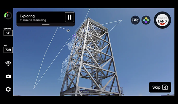
Skydio 3D Scan uses AI to automate photographic data collection and mapping infrastructure inspection and accident scene reconstruction.
Get news, papers, media and research delivered. Sign up for our free newsletters.
Stay up-to-date with news and resources you need to do your job. Research industry trends, compare companies and get weekly market intelligence with Robotics 24/7.

Skydio
Skydio 3D Scan uses AI to automate photographic data collection and mapping infrastructure inspection and accident scene reconstruction.
Skydio Inc. this week announced the general availability of its Skydio 3D Scan adaptive scanning software. The Redwood City, Calif.-based company also said that Bentley Systems Inc. has joined its technology partner ecosystem as a preferred photogrammetry provider for 3D Scan datasets.
Skydio 3D Scan adds artificial intelligence to drones to automate image collection and mapping tasks, ranging from infrastructure asset inspection to crime and accident scene reconstruction, said the company.
“We are extremely excited about the value that 3D Scan delivers," stated Hayk Martiros, vice president of autonomy at Skydio. "Manual drones lack the ability to see and understand the 3D nature of the world and, as a result, can't provide a scalable solution to replace traditional methods of inspection."
"With 3D Scan, we are turning Skydio drones into intelligent scanning robots that can build real-time flight plans optimized to each scene and generate the best possible photographic datasets," he added. Skydio was founded in 2014 and raised $170 million in Series D funding in March.
Traditional asset inspections performed by workers using bucket trucks, ropes, and ladders are dangerous, time-consuming, inaccurate, and often damaging for the environment. Drones have emerged as a valuable tool to conduct visual inspections and gather critical data without putting operators at risk. Drone inspections can generate useful datasets without putting inspectors at risk.
But the complexity, crash risk, and training costs of manual drones have greatly limited their ability to generate useful data, said Skydio. These capture workflows are especially critical as the industry transitions from providing inspection reports consisting of handwritten notes and photographs of structures to fully immersive, annotated 3D models that enable measurements and continuous status tracking, it said.
Manually piloted drones require cumbersome mission planning, constant access to GPS, and intense focus from an elite pilot to avoid collisions, when inspection teams should be focused on how to capture the best data instead.
Skydio described 3D Scan as adaptive mapping software that extends the Skydio Autonomy engine to generate tailored flight paths in real time for digitization of any asset or scene. With automated data capture using 3D Scan for asset inspection and scene reconstruction, any inspector, surveyor, or first responder can efficiently capture a complete photographic dataset that documents every angle of a scene, said Skydio.
The company claimed that its product will ensure accurate coverage with sub-millimeter precision in a fraction of the time while greatly reducing risk. Skydio said that 3D Scan offers the following benefits:
The technology comes to market battle-tested after months of trials with leading organizations, including Sundt Construction, North Carolina Department of Transportation (NCDOT), and the Boston Police Department. Early-access participants have reported up to 75% faster data capture, 50% greater inspection team output, and 30% lower rates of reinspection, or needing to refly the structure due to incomplete data on the first attempt.
“We have been amazed by the results we achieved using 3D Scan during the Early Access Program," said Dean Miller, a virtual construction engineer at Sundt Construction. "Our teams will be able to get in the field faster and better serve our clients through the business development, operations, and close-out processes.”
First responders will soon be able to store and manage chain of custody for their 3D Scan datasets using Skydio’s integration with Axon Evidence.com. This workflow gives public safety operators new tools for presenting full evidence of crime and accident scenes.
3D Scan is available for Skydio 2 now, with Skydio X2 availability coming soon. The software can be purchased as an optional add-on to any Skydio 2, starting at $2,999 per drone per year, or as part of new vehicle and software bundles.
Bentley Systems provides engineering software for global infrastructure. The Exton, Pa.-based company said its software is used for the design, construction, and operations of water and wastewater, public works, and campus facilities, among others.
Bently's offerings include MicroStation-based applications for modeling and simulation, ProjectWise for project delivery, AssetWise for asset and network performance, and the iTwin platform for infrastructure digital twins. The company said it employs more than 4,000 people worldwide and generates annual revenues of more than $800 million.
Bently's ContextCapture is a reconstruction engine that can now use Skydio 3D Scan datasets to generate 3D models, along with DroneDeploy and RealityCapture. Skydio claimed that the high-quality and accurate imagery from Skydio 3D Scan generates better 3D models than current manual drone workflows, which limit the performance of reconstruction engines.
“We are excited to partner with Skydio to help our users safely, reliably, and repeatedly generate the photo datasets required to create amazing 3D models and digital twins," said Robert Mankowski, senior vice president of digital cities at Bentley. "Infrastructure assets like roads and bridges, rail and transit systems, utilities, and buildings and industrial facilities are very complicated, and capturing them accurately and precisely is hard to do manually."
"Combining the Skydio drone automation with the high-performance and highly scalable 3D reconstruction capabilities of Bentley’s ContextCapture will enable our users to create great models, more frequently, and more cost-effectively than before," he said.
3D Scan builds a real-time model of the scene, allowing the drone to automate the data capture process needed to generate 3D models with comprehensive coverage and high resolution.
From geometry preparation to AI-assisted analysis, integrated CFD workflows…
Software-based GripperAI manages mixed picking through basic geometry
Safety, communication and motion control components enable smooth operation

North America’s largest robotics and automation event winds down