Saildrone Inc. is making a splash in autonomous oceanic monitoring by “sailing seas of data,” according to NVIDIA Corp. The startup’s nautical data-collection technology has tracked hurricanes in the North Atlantic, discovered a 3,200-ft. underwater mountain in the Pacific Ocean and begun to help map the entirety of the world’s ocean floor.
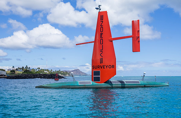
Alameda, Calif.-based Saildrone develops autonomous uncrewed surface vehicles (USVs) that carry a wide range of sensors. NVIDIA Jetson modules process its data streams for artificial intelligence at the edge. They are optimized in prototypes with the NVIDIA DeepStream software development kit (SDK) for intelligent video analytics.
Saildrone said it is seeking to make ocean data collection cost-effective, offering systems for science, fisheries, weather forecasting, ocean mapping, and maritime security. The company offers three different USVs, and its Mission Portal control center service is used for monitoring customized missions and visualizing data in near real time.
In addition, some of Saildrone’s historical data is freely available to the public.
“We’ve sailed into three major hurricanes, and right through the eye of Hurricane Sam, and all the vehicles came out the other side—they are pretty robust platforms,” said Blythe Towal, vice president of software engineering at Saildrone, referring to a powerful cyclone that threatened Bermuda in 2021.
Founded in 2012, Saildrone has raised $190 million in funding. The startup is a member of the NVIDIA Inception program, which provides startups with technology support and guidance on AI platforms.
AI to watch waters worldwide
Saildrone is riding a wave of interest in use of its crewless data-collection missions for environmental studies of oceans and lakes, stated NVIDIA.
The University of Hawaii at Manoa has enlisted the help of three 23-foot Saildrone Explorer USVs to study the impact of ocean acidification on climate change. The six-month mission around the islands of Hawaii, Maui, Oahu, and Kaui will be used to help evaluate the ocean’s health around the state.
Ocean acidification is a reduction in its pH, and contributing factors include the burning of fossil fuels and farming. These can harm coral, oysters, clams, sea urchins and calcareous plankton, in turn threatening marine ecosystems, explained the university.
Saildrone recently partnered with Seabed 2030 to completely map the world’s oceans. Seabed 2030 is a collaboration between the Nippon Foundation and the General Bathymetric Chart of the Oceans, or GEBCO, to map ocean floors worldwide by 2030.
“Saildrone’s vision is of a healthy ocean and a sustainable planet,” said Richard Jenkins, founder and CEO of Saildrone. “A complete map of the ocean floor is fundamental to achieving that vision.”
NVIDIA claimed that the scientific community worldwide is embracing its AI for climate studies, including for hyper-local climate modeling, improving carbon sequestration, renewable energy research, and many other areas. Dedicating its own expertise, the company added that it is developing “the world’s most powerful AI supercomputer for predicting climate change,” named Earth-2, which will be used to create a digital twin of Earth in Omniverse.
Saildrone uses energy-efficient data processing
Saildrone said its USVs enable researchers to collect more data using fewer resources than traditional boats and crews, conserving energy and keeping crews out of danger.
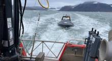
The company has built its USVs for harsh weather and long missions. One robot recently completed a 370-day voyage monitoring carbon dioxide, sailing from Rhode Island across the North Atlantic to Cabo Verde, down to the equator off the west coast of Africa, and back to Florida.
Running mostly on solar and wind power requires energy-efficient computing to handle so much data processing, said Saildrone.
“With solar power, being able to keep our compute load power efficiency lower than a typical computing platform running GPUs by implementing NVIDIA Jetson is important for enabling us to do these kinds of missions,” said Towal.
Oceanic surveying meets edge AI
Saildrone relies on the NVIDIA JetPack SDK for access to a full development environment for hardware-accelerated edge AI on the Jetson platform. It runs machine learning on the module for image-based vessel detection to aid navigation, said NVIDIA.
Saildrone pilots set waypoints and optimize the routes using “metocean” data—which includes meteorological and oceanographic information—returned from the vehicle. All of the USVs are monitored around the clock, and operators can change course remotely via the cloud if needed.
Machine learning is mostly run locally on the Jetson module—but can run on the cloud as well with a satellite connection—because bandwidth can be limited and costly to shuttle from its robust suite of sensors producing high-resolution imagery.
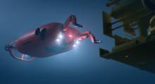
The USVs have oceanographic sensors for measurement of wind, temperature, salinity and dissolved carbon. Saildrone said it also enables research of ocean and lake floors with bathymetric sensors, including deep sonar mapping with single- or multi-beam for going deeper or wider.
Saildrone's perceptual suite also includes radar and visual underwater acoustic sensors.
DeepStream goes into the deep sea
Saildrone has used the NVIDIA DeepStream SDK for its vision AI applications and services. Developers can build seamless streaming pipelines for AI-based video, audio, and image analytics using the kit.
Offering a 10x throughput improvement, DeepStream can be applied from edge to cloud to develop optimized intelligent video applications that handle multiple video, image, and audio streams, asserted NVIDIA.
Saildrone said it plans to rely on DeepStream for image preprocessing and model inference, which enables machine learning at the edge, even at sea while powered by sun and wind.
The company this week announced that it plans to deploy 12 drones to support National Oceanic and Atmospheric Administration (NOAA) hurricane forecasting.
Article topics
Email Sign Up

Related Marine News