Found in Robotics News & Content, with a score of 0.39
June 04, 2023
…swarms of aircraft and drones to fly independently without GPS or communication networks. On the other hand, the U.S. Defense Advanced Research Projects Agency (DARPA) recently finalized its first live-flight demonstration of air combat algorithms with an F-16 fighter jet. This was a big step forward in DARPA’s Air Combat Evolution (ACE) program, established in 2019. Data-driven advanced algorithms will transform everything from air traffic control, ticket pricing, crew and maintenance planning, and language processing in cabins and aircraft assembly. Autonomous aircraft software examples Numerous products are available in the autonomous aircraft software market. Here are a few trending examples:…
Found in Robotics News & Content, with a score of 1.04
April 18, 2023
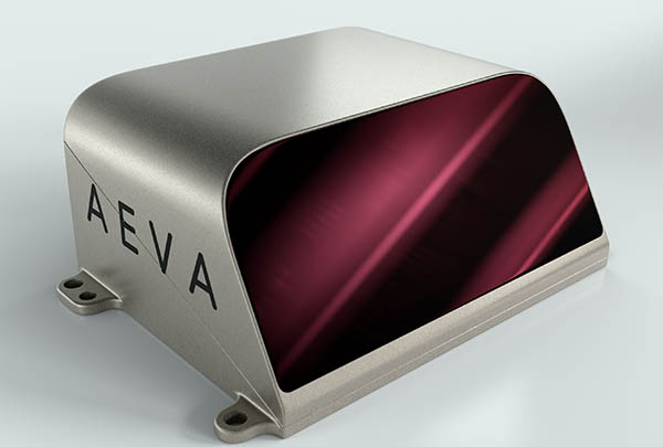
…with six degrees of freedom for accurate positioning and navigation without the need for additional sensors, like IMU or GPS. Aeries II is the first sensor on the market to integrate Aeva’s lidar-on-chip technology, the Mountain View, Calif.-based company said. It integrates all key sensor components including transmitters, receivers, and optics onto a compact silicon photonics module. This design uses no fiber optics, resulting in a highly automated manufacturing process that allows Aeva to manufacture at scale and lower costs to meet the needs of automotive OEMs and other volume customers.
Found in Robotics News & Content, with a score of 0.31
April 14, 2023
…conditions they might encounter in outdoor environments and in GPS-denied situations as well. A lot of that work in recent years has involved underwater robots because that is really where some of the toughest unsolved problems are right now in robot navigation. There are a lot of unique challenges in that domain. Submerged underwater, you don't really have access to the electromagnetic spectrum, so you can't communicate via Wi-Fi radio. You can't receive GPS information. Your ability to see what is around is degraded as well. Cameras don’t' work as well underwater. … So we have to take advantage of…
Found in Robotics News & Content, with a score of 0.62
April 13, 2023
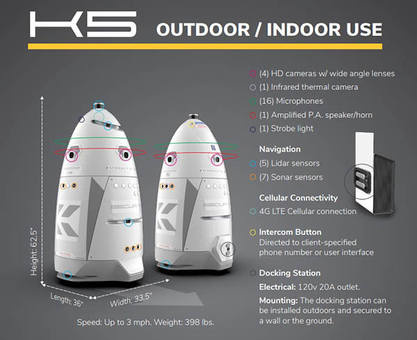
…Boston Dynamics, which the city are calling “Digidogs,” and GPS tracking systems developed by StarChase. “We are scanning the globe on finding technology that will ensure this city is safe for New Yorkers, visitors and whomever is here,” Adams added. “If we were not willing to move forward and use technology on how to properly keep cities safe, then you will not keep up with those who are doing harmful things to hurt New Yorkers.” At the conference, NYPD Chief Jeffery Maddrey said the city is leasing the Knightscope robot from the company as part of a six-month pilot. The…
Found in Robotics News & Content, with a score of 0.49
April 07, 2023
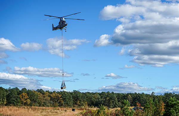
…take off, fly, and land safely, with or without GPS. Its systems serve aerial mobility applications for partners in the commercial and defense sectors. The company said it bridges the gap between aerospace and robotics with complete systems that improve efficiency, performance, and safety for aircraft ranging from small drones to full-size helicopters. Drones fly in critical window Blood loss is a leading non-age-related cause of death for both warfighters and civilians. Traditional responses to blood loss involve humans transporting supplies to the injured with trucks or helicopters, or the storage of large amounts of medical supplies. This can lead…
Found in Robotics News & Content, with a score of 0.44
March 10, 2023
…fully automated system can eliminate small drones without using GPS or radio-frequency jamming. Launched from a designated pod, the interceptor flies autonomously towards the targets based on initial radar guidance, then “locks on” to the target with advanced machine vision. The intercepting drone follows the target, then incapacitates and captures it, using a net and a parachute to safely lower it to the ground. The whole process is fully automated without the need for a human pilot, said Iron Drone. Airobotics completed its acquisition of Iron Drone's assets on March 6. The company presented the government-grade system at the World…
Found in Robotics News & Content, with a score of 0.57
March 06, 2023
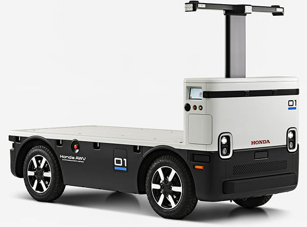
…uses a suite of sensors to operate autonomously, using GPS for location, radar and lidar for obstacle detection and cameras for remote monitoring, the company noted. Previous field tests have also successfully verified that multiple Honda AWVs can transport and deliver construction materials and supplies at precise points along a pre-set route. The vehicle uses Honda's extensive portfolio of mobility technologies, using common components from its automobiles and other products. As Honda aims to commercialize AWV, the company said it is looking for partners to participate in field testing, as well as to improve functions and enhance services, especially in…
Found in Robotics News & Content, with a score of 0.79
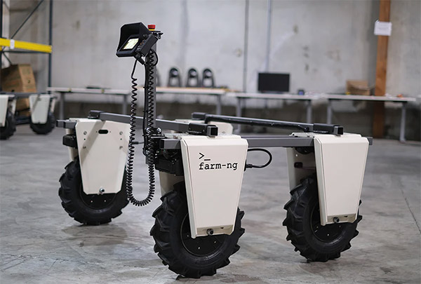
March 02, 2023
…vehicle for farms big and small. The system uses GPS-denied vision navigation technologies that the company developed for the landing of the Blue Ghost spacecraft on a precise location on the Moon’s surface. The Amiga incorporates the latest in precision agriculture techniques to maximize yields while reducing workload, facilitating data collection, improving safety, and reducing soil compaction, claimed farm-ng. Farmers can adjust the system to different row widths, and it can accommodate a wide variety of add-on tools. In addition, the Amiga can be ridden or operated remotely, said the company. As the vehicle becomes fully autonomous, it will further…
Found in Robotics News & Content, with a score of 0.34
January 24, 2023
…components such as motors, breaks, and battery External factors: GPS and local weather conditions After all this data is processed, essentially customers get access to a storyboard of their projects. Instead of entering the project data manually, the data is transferred from LIFTBOT to ONSITE completely automatically. Now a team lead can check the project status online and also receive automatic daily notifications on the project status. If something doesn't go according to the plan, the leader has the opportunity to intervene promptly. This way, the problems can be discovered days and weeks earlier, preventing schedule and cost overruns. One…
Found in Robotics News & Content, with a score of 0.37
December 18, 2022
…a supercomputer, a drive-by-wire system, six optical sensors, six GPS/GNSS units, a low-level computer, a BP/Cisco network switch, and wireless communications.” “If you look at the cockpit, packaging, harnesses, wiring, aerodynamics, and connectivity of these vehicles, we're addressing constraints,” he said. “Compared with commercial [self-driving] vehicles on the roads, if you open their trunks, you'd see wires everywhere and server racks—that's not yet automotive-grade. Our racecars don't have lidar domes, but Luminar 3D-printed a cockpit cover.” “Our sponsors often send engineers to our shop in Indianapolis,” Mitchell added. “They want to see their technologies pushed to the absolute limit and…
Found in Robotics News & Content, with a score of 0.35
December 13, 2022
…an “unload on the go” operation using a precise GPS signal. This can decrease grain spillage from miscommunication or imperfect unload coordination and reduce operator stress, the company said. “Ultimately, the Driver Assist Harvest Solution simplifies the complexity of harvest operation, giving operators peace of mind with the push of a couple of buttons,” according to Raven. Raven Industries collaborates with CNH Raven Industries said it is developing more driver-assist and autonomous systems and that its “holistic solution ensures that all settings are automatically accounted for, including propulsion, guidance, and functional controls.” “Driver Assist technology will allow anyone to operate…
Found in Robotics News & Content, with a score of 1.49
December 09, 2022
…take off, fly, and land safely, with or without GPS. It has designed systems to enable aerial mobility applications for partners in the commercial and defense sectors. The Pittsburgh-based company claimed that it bridges the gap between aerospace and robotics with complete systems that can improve efficiency, performance, and safety for aircraft ranging from small drones to full-size helicopters. Pittsburgh Technology Council honors local leaders The Pittsburgh Technology Council recognized Near Earth as an innovator of the year. Source: Near Earth Autonomy The Pittsburgh Technology Council said it celebrates the most successful and innovative technology companies in Southwestern Pennsylvania at…