Found in News and Content
…self-navigation without needing a map, GPS, or wireless infrastructure. The result is a detailed and accurate map collected with minimal human intervention and risk, the companies claimed. “The integration of autonomous surveying technology into a construction workflow has groundbreaking potential,” said Aviad Almagor, vice president of technology innovation at Trimble. “It can improve operational efficiency and transparency throughout the build…
Found in News and Content
…adds a distribution node for GPS Platform Services. The company plans to share with retailers the expertise and capabilities it has developed over the decades. The Texas center also adds another fulfillment node for the new Logistics-as-a-Service program that Gap will begin offering to other retailers, especially smaller brands and startups. GPS Platform Services by Gap Inc. will offer e-commerce…
Found in News and Content
…both indoors and outdoors, so GPS is optional—we can localize based on purely visual features.” In addition, Cartken is a member of NVIDIA Inception, a program to help startups with GPU technologies, software, and business development. Cartken uses NVIDIA Jetson for sensing and navigation. Source: NVIDIA Cartken delivery robots roll out to campuses Cartken’s robots are serving Grubhub deliveries at…
Found in News and Content
…AMRs. “Think of it like GPS,” said Locus Robotics’ Walker. “Once people realize what it enables, they’ll find new applications.” “Users don’t want interoperability,” InOrbit’s Pestoni said. “It’s just a stepping stone to orchestration of their facilities and greater efficiency.” Editor's note: Open Robotics responded to the discussion about OpenRMF, and its comments have been added to this article.
Found in News and Content
…platform that it said provides GPS-based navigation for faster, more efficient autonomous vehicle development. The company said OutdoorNav is compatible with its outdoor mobile robots and third-party industrial vehicles. “Robotics product development can often be a difficult, sometimes harrowing experience,” stated Bryan Webb, president of Clearpath Robotics. “Building a robust navigation system is expensive and risky, and it may prevent…
Found in News and Content
…safety, telemetry data offload, and GPS timing alignment. The connectivity infrastructure includes Cisco Ultra-Reliable Wireless Backhaul for highly reliable mobile connectivity and Cisco Catalyst Industrial Ethernet switches to connect in-vehicle sensors and on-board compute. The same Cisco technologies powering the IAC are used to connect and secure critical systems and improve operations across industries like manufacturing/industrial automation, roadways, and ports.…
Found in News and Content
…networks needed to work without GPS for the robot to do things such as navigate and find a charging station. They were trained with high-frequency features tracked across frames to get an estimate of pose and trajectory. Walking seems easy to humans, but it involves physical awareness of limbs, an energy-efficient gait, balance, and coordinated motion of all limbs, said…
Found in News and Content
…an additional distribution node for GPS Platform Services, a new fulfillment service Gap Inc. is rolling out to share with retailers that are struggling in their fulfillment processes the expertise and capabilities it has developed over the decades. The new facility brings the number of U.S. e-commerce fulfillment centers to 7 plus an additional DC in Canada. The list includes…
Found in News and Content
…optical sensors. It has advanced GPS systems. It has a supercomputer drive-by-wire system. It also has wireless communication technology from Cisco that allows the vehicles to communicate with each other and with race control. All in all, these vehicles are about over a million dollars in terms of hardware and software and technology. Does the university raise funds through sponsorship…
Found in News and Content
…quickly develop and deploy advanced GPS, light, and other sensors using field-tested software solutions, the companies said. Helping companies deploy faster AAEON said it partnered with Cogniteam to develop hardware systems that come with various foundational capabilities- all of which are pre-integrated with Nimbus. Without this key advantage, operators lack cloud-connected capabilities, which allow for over-the-air updates, monitoring, insights, and…
Found in News and Content
…uses UWB technology to achieve GPS-like capabilities indoors at a low cost with two products. ARINAlert is a collision-avoidance system intended to improve worker situational awareness and reduce forklift accidents. ARINTrack is an indoor positioning system 〈IPS〉 that allows customers to track and find company assets in any type of facility. ARIN said its proprietary systems can mitigate risk and…
Found in News and Content
…components such as lidar and GPS to be modular. RC Mowers continues demonstrations The automated lawncare industry is growing, but Kubista said he isn't worried about competition. “There are about 20 players taking different technical approaches with different business models, and we hope they all succeed,” he said. “If we were the only ones out there, it wouldn't seem like…
Found in News and Content
…Global Navigation Satellite System—which contains GPS+GLONASS+BEIDOU+GALILEO,” the company told Robotics 24/7. “The fundamentals of GNSS calculate the position of the receiver by mixing the distance from the satellite and receiver itself.” “RTK positioning can reduce the factors that affect the GNSS signal accuracy and achieve accuracy within the centimeter level through the double difference between the GNSS signal received by…
Found in News and Content
…growth of factory automation,” said Jeffrey Smith, general partner of SIP GP. “We see very large scale and highly defensible market potential worldwide.” This investment will support READY’s global expansion and speed up the integration and deployment of the READY Robotics Forge/OS with NVIDIA Omniverse Isaac Sim, the companies said.
Found in News and Content
…pre-recorded driving information and geometric GPS data to accurately navigate a predetermined route. This package ensured that the vehicle was positioned to within 2 cm (0.7 in.) of the impact point. It hit the wall at precisely 130.015 mph (209.238 kph) and was within 1 degree of the prescribed angle. The test used AB Dynamics’ SR60 robot for steering, its…
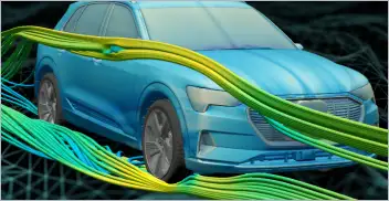
From geometry preparation to AI-assisted analysis, integrated CFD workflows…
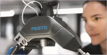
Software-based GripperAI manages mixed picking through basic geometry
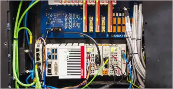
Safety, communication and motion control components enable smooth operation
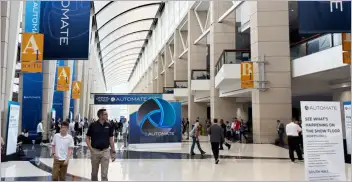
North America’s largest robotics and automation event winds down