Niantic Spatial
VPS 2.0 is Niantic Spatial's new visual positioning system. The company also launched the Scaniverse platform.
Get news, papers, media and research delivered. Sign up for our free newsletters.
Stay up-to-date with news and resources you need to do your job. Research industry trends, compare companies and get weekly market intelligence with Robotics 24/7.

Niantic Spatial
VPS 2.0 is Niantic Spatial's new visual positioning system. The company also launched the Scaniverse platform.
AI company Niantic Spatial announced the launch of two new platforms, which the company said build a foundation for world models for humans and machines.
The company launched Scaniverse, the entry point to its spatial intelligence services and Large Geospatial Model, and VPS 2.0, a precise visual positioning platform that works at a global scale without any prior scanning required.
Capturing a space and knowing exactly where you are within it are two different problems. Whereas most companies solve one, Niantic Spatial said that it solves both by creating geometrically accurate and spatially grounded models that allow machines to understand and interact with the physical world.
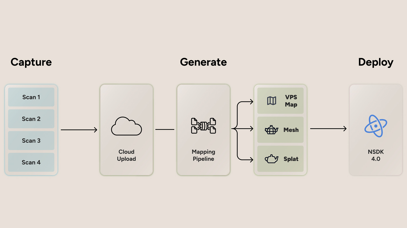
Niantic Spatial said that Scaniverse is its self-serve platform for delivering spatial services: it powers data capture and upload, generation of spatial assets, inspection of meshes and splats and localization with VPS.
Scaniverse supports versatile capture of physical space, ranging from individual rooms to areas of thousands of square meters.
Unlike traditional scanning platforms, Niantic Spatial said that Scaniverse works with regular consumer phones - and now with data from 360° cameras, no expensive proprietary equipment or training required.
Niantic Spatial released an updated Scaniverse app that builds on a platform already used to scan millions of objects and places in the real world. Scaniverse on the web is a browser portal where teams can upload, manage and process data from the Scaniverse mobile app and 360° cameras and visualize outputs directly in the viewer.
Click here to learn more about Scaniverse details and updates.
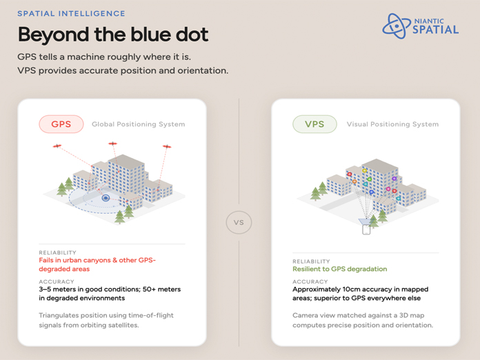
Niantic Spatial said that its Visual Positioning System (VPS) delivers precise, real-time position and orientation using camera input and advanced computer vision. The company said that this is essential for robots navigating complex sidewalks, field technicians finding a specific valve in an oil refinery, AI glasses understanding their surroundings, or aerial drones coordinating with the ground.
Niantic Spatial said that VPS delivers six degrees of freedom (6DoF) localization - full position and orientation - accurate to centimeters, compared with the 3-5m accuracy of GPS in favorable conditions, and far more precise than what GPS can provide indoors, underground or in GPS-degraded environments.
Click here to learn more about Niantic VPS.
Niantic Spatial said that Scaniverse and Niantic Spatial VPS are designed for use across:
The company said that these updates are focused on the “Capture, Reconstruct, and Localize” services in its Large Geospatial Model.
Later in 2026, the company said it plans to share more on its spatial foundation models for semantic understanding of scenes, which will enable AI to not only navigate the world but also to reason about the objects and environments within it.
Enjoyed this article? Add Robotics 24/7 as a preferred source in Google Search.
Edge computing gives AI agents the processing power to turn instructions into…
Daimon-TWM world model debuts for the public
Platform helps robots adapt to complex tasks

Look beyond the headlines for the latest in humanoid robots