Found in News and Content
…like DHL’s MySupplyChain application and GPS tracking for final mile delivery, will provide engineers with additional transparency, visibility and control over their orders and returns. The 260,000 square-foot Memphis WDC is expected to open in October, with DHL owning the entire 422,000 square-foot facility, which DHL said was the first speculative distribution facility built in Memphis going back to 2007.…
Found in News and Content
…deployment is global positioning system 〈GPS〉 technology—in use by 18% currently, but with 28% planning to deploy within 12 months. The survey’s findings regarding equipment maintenance showed an increase in outsourcing. This year, 18% said that they outsource maintenance of automated systems, up 2% from last year. Additionally, 32% use a combination of internal staff as well as outsourcing for…
Found in News and Content
…environments. Great for outdoor applications, GPS has struggled to provide effective locationing in increasingly tall and dense facilities. These facilities are also less ideal for hardwired sensor retrofits, so Locix decided early on to pursue wireless communication. Although a lot of potential remains in RFID, the world is driven by bar codes for inventory management, Pavate says. Bluetooth can wirelessly…
Found in News and Content
…shipments using a combination of GPS and wireless connectivity. 5G takes that to the next level, as low latency means continual, up-to-the-second tracking of exactly where goods are. With real-time location tracking, LSPs will gain the ability to: Provide live status updates to their customers Understand potential delays when shipping Use AI to optimize fleet routes, based on the latest…
Found in News and Content
…gate system GROUND - RFID, GPS, cellular tracking system and in-cab tasking system AIR - RFID, GPS, Optical tracking system Enterprise Yard Management Visibility PINC’s Enterprise Visibility Suite allows organizations to easily view, gain insights and analytics, and manage yards, facilities, and transportation execution activities as integrated operations. INFOGRAPHIC: See the ways that a real digital yard management system can…
Found in News and Content
…All also have IMUs and GPS and most have ultrasound sensors for near-field sensing. A critical choice is whether to use LIDAR-only, stereo-vision-only, or hybrid. LIDAR can give excellent 360deg ranging information with spatial resolution and a dense point cloud which enables good signal processing. LIDARs however have are expensive and can have near-field (a few cm) blind spot. The…
Found in News and Content
…data collection and processing and GPS to improve visibility of shipments and improve fill-rate for quite some time now. If we take an example of Jabil, its Intelligent Digital Supply Chain (IDSC) systems can improve strategies, innovation, and design throughout the supply chain, delivering superior financial performance and customer experience which include Jabil InControl, Procurement Solutions and Supply Chain solutions.…
Found in News and Content
…safely and at scale in GPS-denied environments. We deploy these robots inside of warehouses in just days, with minimal behavioral changes or effects on a warehouse's day-to-day operations. The drones wake up on a schedule, capture data of their assigned section of the warehouse, and then go back home to sleep - recharging their batteries and uploading their data to…
Found in News and Content
…contributes to increased uptime.” Telemetry’s GPS capability and supporting fleet software dispatch also allow the dealer or service provider to communicate around service arrival times so that any asset needing service is pulled into the appropriate service bay or other area, rather than wasting time trying to locate the lift truck needing service. “The technician can pull up and immediately…
Found in News and Content
…ballast, ultrasonic wind measurement and camera/GPS integration. So while the point is not so much to produce some radical new boat design as it is to exercise the engineering process to solving these challenges, there have been incremental innovations that could be implemented on ocean drones. DE: Does WPI, or the consortium of organizers of this competition, have a particular…
Found in News and Content
…avoid obstacles, navigate indoors without GPS, land precisely on docking stations, operate in fleets and be remotely managed. The business benefits from drones are significant and immediate given low capital expenditure & infrastructure investments, access to reliable, off-the-shelf drone hardware, and SaaS offerings for warehouse automation. API-based integration makes it easy for existing warehouse management systems to onboard autonomous drone…
Found in News and Content
…as radar, laser/lidar, camera and GPS, according to the company. PreScan also can work with accident information, such as road traffic accident data from the German In-Depth Accident Study (GIDAS) project. “In PreScan, you can have a cyclist jump out in front of your car; you can change the weather from rainy to snowy to icy; and you can add…
Found in News and Content
…technologies, especially RFID, Bluetooth and GPS. There’s strong demand across the supply chain for greater visibility. These technologies can be built right into all types of packaging including totes, bulk and pallets. The technologies provide a front-line view of what is where and when. You could call them cousins of the Internet of Things. People are starting to get their…
Found in News and Content
…including UWB, BLE, global-positioning system 〈GPS〉 sensor data and RFID. Nehrenz says it’s important that a location platform can work with multiple edge technologies. While in some instances a BlueCats software engine is used on its own, through the vendor’s application programming interfaces (APIs), the location engine can pass information to warehouse management system 〈WMS〉 or labor management solutions, says…
Found in News and Content
…to reference implementations of loosely-coupled GPS/INS. Third is a full Developer Site and tools with charting, graphing and algorithm simulation. “OpenIMU enables advanced, easy-to-deploy localization and navigation algorithm solutions for a fraction of the time and cost of traditional methods. OpenIMU's combination of open-source software and low-cost hardware enables rapid development of advanced solutions for drones, robotics, and autonomous applications,”…
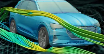
From geometry preparation to AI-assisted analysis, integrated CFD workflows…
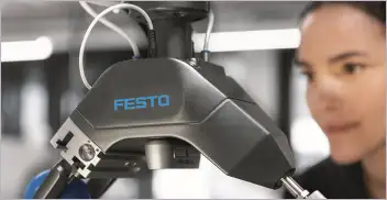
Software-based GripperAI manages mixed picking through basic geometry
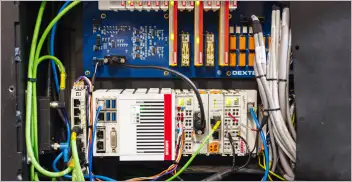
Safety, communication and motion control components enable smooth operation

North America’s largest robotics and automation event winds down