Found in News and Content
…manufacturers with systems for mapping, navigation, obstacle avoidance, and risk avoidance. The MOV.AI Robotics Engine Platform, combined with Velodyne’s Puck lidar sensors, will meet the growing demand for automation in dynamic collaborative environments such as e-commerce, logistics, manufacturing, and hospitals, they said. “MOV.AI’s mission is to simplify collaborative robot development and to provide AMR [autonomous mobile robot] manufacturers and integrators…
Found in News and Content
…for our robotic autonomy and navigation,” said Michael Blanton, chief technical officer at Renu Robotics. “The power-efficient sensors enable the Renubot to deliver an automated vegetation management system that is repetitive and reliable to keep facilities operating at peak performance, while controlling costs.” Renu Robotics said it is developing innovations in artificial intelligence, situational awareness via sensors and other technology.…
Found in News and Content
…be made. Furthermore, the range, navigation, and communication challenges would also be demonstrated at scale. However, such an autonomous system for railways isn’t as simple as it might seem. The environment of the railway infrastructure is surprisingly tough for autonomous devices. For example, there are some places with no communications or GPS (such as tunnels and Faraday cages), few opportunities…
Found in News and Content
…to integrate secure and reliable navigation systems that are interoperable with the European maritime logistics network.” Flying ships and drones to make fast deliveries Flying Ship Technologies is developing autonomous ground-effect vessels that fly just over the water. The Leesburg, Va.-based company claimed that they are 10 times faster than boats and are one-quarter of the cost to maintain and…
Found in News and Content
…and provide mapping for alternate navigation if GPS guidance fails. Honeywell said its BVLOS suite will allow drone designers to combine data in new ways to save weight and power. Its radar computes an avoidance path using built-in circuitry, rather than requiring a separate processor. Its satellite uplink can be used to download real-time weather and traffic reports from other…
Found in News and Content
…including visual-intertial odometry (VIO) and navigation in GPS-denied environments. “Situational awareness and obstacle avoidance enable BVLOS [beyond visual line-of-sight] and follow-me applications,” said Singh. “I'm really excited about unmanned aerial mobility—you could call Uber Elevate [acquired in December by Joby Aviation] and go from San Francisco to San Jose in a self-driven aircraft.” 5G and robotics “5G is fundamental to…
Found in News and Content
…and plug-and-play modules for autonomous navigation and the use of Wi-Fi, 4G, and 5G networks. Qualcomm collaborates with spinoff ModalAI partnered with Qualcomm to design and develop the Qualcomm Flight RB5 5G and plans to support it through its lifecycle with open-source software. The platform is intended to enable developers and original equipment manufacturers (OEMs) to build drone and flight…
Found in News and Content
…vehicles. “In combining Honeywell’s best-in-class navigation sensors with leading-edge GPS resilience technology from InfiniDome, we’re working to develop a first-of-its-kind holistic solution built on tightly integrated layers of protection for all uses of navigation for unmanned air and ground vehicles,” said Omer Sharar, CEO of InfiniDome. InfiniDome said it provides front-end cybersecurity to protect wireless communications from jamming attacks. The…
Found in News and Content
…Honeywell offers avionics, flight control, navigation, radar, communications, actuation, cooling, motors, and turbo-electric propulsion systems for the emerging urban air mobility (UAM) segment. The systems are all tailored for piloted VTOL, UAM, and unmanned cargo vehicles, it said. Honeywell also offers aerospace integration and certification expertise for enabling the commercialization of these vehicles. Pipistrel provides UAV capabilities for multiple applications…
Found in News and Content
…localization technologies are emerging for navigation to pin-point damage mechanisms, as well as provide reproducible data. These deliverables can help predict the future safety of the sites being inspected. Challenges inside GPS-denied environments The main reason for sending mobile robots for inspection, maintenance, and repair is to avoid putting employees in dangerous situations. Inspections are necessary for identifying, predicting, and…
Found in News and Content
…ensure 360-degree vision for precise navigation and operations. “We learned from the MiR250 that cross-eyed cameras in addition to 3D sensors can see more above and below than safety-rated lidar,” Charles said. “The 3D cameras were there for object detection, but the new cameras can see overhanging objects or obstacles on the ground ahead of time.” The new AMRs are…
Found in News and Content
…robots include the most advanced navigation system in the industry and can adjust to their environments and reroute in real time. Vecna's proprietary Pivotal orchestration engine integrates with existing warehouse management systems for a coordinated approach that maximizes throughput, operational efficiency, and human-robot collaboration. Pivotal can simplify warehouse management by analyzing an organization’s operations in real time and adjusting processes…
Found in News and Content
…and software algorithms mean that navigation and vision become more and more precise,” he added. Service robotics to grow 40% In addition to AMRs in logistics, the IFR forecast that unit sales for mobile and service robots in public environments worldwide will grow by 40% per year. “Mobile robots have traditionally operated in industrial settings to transport parts throughout the…
Found in News and Content
…functioning of the vehicle's laser-based navigation sensors, slowing down its rate of travel. Cody adds: “Speaking in generalities, most AMRs in the field run on minimal, if any, suspension. So, every time they travel over an area in the floor with excessive wear, a bump, or a gap, the potential exists for the navigation system to be disrupted — even…
Found in News and Content
…ingredients in robotic autonomy and navigation. They allow mobile robots to extend outside controlled situations with pre-defined tasks and function in unfamiliar and unpredictable settings. The company added that its lidar can provide real-time 3D perception data for localization, mapping, object classification and object tracking. Combining high-resolution image data with a broad vertical field of view, the sensors detect the…
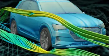
From geometry preparation to AI-assisted analysis, integrated CFD workflows…

North America’s largest robotics and automation event winds down

Automate’s largest day ever draws huge crowds to McCormick Place

North America’s largest robotics and automation event kicks off