Found in News and Content
…simultaneous localization and mapping (SLAM), GPS-denied indoor navigation, high-resolution 4K imagery, and ultrasonic object detection for added safety. Qualcomm's latest products also suport 4G LTE, Bluetooth, and Wi-Fi in addition to 5G, said Singh in response to a question during the briefing. In addition, it includes support for Linux and the Robot Operating System 〈ROS〉. Interest in the RB5 is…
Found in News and Content
…for movement designed specifically for GPS-denied autonomous UAVs [unmanned aerial vehicles] with obstacle avoidance,” the company said in a release. The San Diego, Calif.-based company added with 5G, “VOXL 2 enhances mission critical navigation, including beyond visual line-of-sight (BVLOS) to support safer, more reliable flight.” New system powered by Qualcomm ModalAI said VOXL 2 is powered by the Qualcomm Flight…
Found in News and Content
…RailPod said it uses lidar, GPS technologies, and more to track geometric measurements, horizontal wear, vertical wear, internal rail flaws, and utility asset mapping. English said the rail pod helps railroad inspections be more efficient. “Here in the States, there are over 200,000 miles of railroad tracks that have to be inspected approximately twice a week,” he said. “That inspection…
Found in News and Content
…featuring self-propelling battery-powered motor and GPS technology to make placing and repositioning marks a breeze—no anchors or mark boats required. It is based out of Detroit, Mich and was founded in 2017 MarkSetBot said its sustainable smart buoys, fixed with wind measurement instruments, will provide WeatherFlow-Tempest's SailFlow App with even more real-time wind data to better inform users. “We're thrilled…
Found in News and Content
…user. The cane also uses GPS and has additional sensors and other features to help a blind person safely walk from one point to another safely (see video at the end of this article). While it is not the first smart cane in use, it is lightweight, relatively inexpensive, and can be easily made at home, said the Stanford students.…
Found in News and Content
…with cameras, microphones, lidar sensors, GPS navigation systems, sonar, and more to help them navigate and survey their environments. Allied Universal Technology specializes in providing safety surveillance products, including video cameras, alarm monitoring, and emergency communication systems. “Partnering with Allied Universal is a perfect recipe for success—robots are deployed to do the monotonous, computational heavy work, while the strategic, hands-on…
Found in News and Content
…Aerial Inc. announced the Robust Navigation System for drones, which integrates GPS anti-jamming technology, a radar velocity system, and an inertial navigation system. The global drone inspection and monitoring market generated $6.44 billion in 2020 and is expected to reach $35.11 billion by 2030, according to Allied Market Research.
Found in News and Content
…inertial measurement units (IMUs) or GPS. This makes autonomous navigation in GPS-denied and featureless environments like tunnels possible, Aeva said. “The improved safety, efficiency, and sustainability of our autonomous trucks are good for fleets, for the public, and for the environment,” said Shawn Kerrigan, co-founder and chief operations officer of autonomous truck developer PlusAI Inc. “Adding Aeva’s 4D lidar to…
Found in News and Content
…The system includes lidar, cameras, GPS, and ultrasonic sensors for precise maneuvering across diverse terrain, said the company. Its firmware can be updated over the air (OTA). Electric Sheep said it monitors all of its mobile robots, which incorporate a safety-rated system capable of detecting perimeter breaches. Dexter is being designed to the evolving R15.08 standard for self-driving robots and…
Found in News and Content
…8R tractor, TruSet-enabled chisel plow, GPS guidance, and additional innovations. The autonomous tractor will be available to farmers later this year. In 1837, John Deere, a blacksmith from Vermont, moved to Illinois, where he found that the local soil stuck to cast-iron plows, noted Jahmy Hindman, chief technology officer of Deere & Co. He invented the first steel plow, and…
Found in News and Content
…robots and drones in complex, GPS-denied environments, companies need to partner to share expertise. Identifying reliable technologies and partners can be a challenge. Exyn Technologies today announced that it has received ISO 9001 certification. The Philadelphia-based company said the globally recognized certification distinguishes businesses with management systems that have been thoroughly tested and audited to meet defined standards in areas…
Found in News and Content
…unstructured environments without relying on GPS connectivity. RR.AI AutoDrive proven for multiple environments RR.AI cliaimed that its AutoDrive “vehicle-agnostic, full-stack” autonomy kit is trusted by OEM partners. The system has already been integrated in a variety of vehicles, including North America’s first automated heavy-duty transit bus, Class 8 trucks, and yard trucks, said the unit. AutoDrive provides “an end-to-end, 360°…
Found in News and Content
…Robust Navigation System, which integrates GPS anti-jamming technology, a radar velocity system, and an inertial navigation system. The companies claimed that the technology is the first resilient system allowing drones to not only safely operate, but also successfully complete their missions, even in GPS-challenged or fully denied environments. Unmanned aerial vehicles (UAVs), from a 20-lb. Class 1 multicopter to a…
Found in News and Content
…robots is not dependent on GPS, so for us, indoors versus outdoors doesn't make a difference.” “Ottonomy splits mapping in a unique way,” he told Robotics 24/7. “We take the geometric map and then add contextual information to it. That's not the case in most AMRs or self-driving vehicles.” Ottonomy teleoperates its robots for the initial mapping, and then its…
Found in News and Content
…portable, rugged and reliable intelligence, surveillance, and reconnaissance (ISR) system for GPS-denied environments, making it ideal for defense use cases, said Cleo. Law enforcement can benefit from a highly intelligent device that can scout areas in advance of deploying officers into high-risk situations. For facility security, the company added, the drone is suitable as a flying surveillance camera.
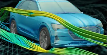
From geometry preparation to AI-assisted analysis, integrated CFD workflows…
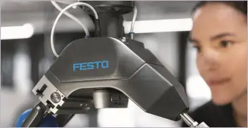
Software-based GripperAI manages mixed picking through basic geometry
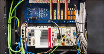
Safety, communication and motion control components enable smooth operation

North America’s largest robotics and automation event winds down