Found in News and Content
…uses a sensor suite including GPS for location, radar and lidar for obstacle detection, and stereoscopic (3D) cameras for remote monitoring. The vehicle also can be operated by remote control. Vehicle dimensions 9' 6” L x 4' 8” H x 4' 11” W Unladen vehicle weight 721 kg (1,590 lb.) Maximum loading capacity 399 kg (880 lb.) Towing weight limit…
Found in News and Content
…land safely, with or without GPS. The Pittsburgh-based company said it “bridges aerospace and robotics with complete systems that improve efficiency, performance, and safety for aircraft ranging from small drones up to full-size helicopters.” Near Earth serves the commercial and defense sectors and won the 2018 Howard Hughes Award, which recognizes outstanding improvements in fundamental helicopter technology. It was also…
Found in News and Content
…Snapdragon 821 chipset, which enables GPS-denied navigation, depth mapping, object detection, obstacle avoidance, and simultaneous localization and mapping (SLAM). The VOXL CAM perception engine has four image sensor concurrencies onboard, including: Time of flight (ToF) for indoor depth mapping Stereo pair image sensors for outdoor depth mapping Tracking image sensor for visual-inertial odometry (VIO) localization It also pre-integrates ModalAI’s Flight…
Found in News and Content
…help, but they typically require GPS to navigate. Kajima Corp., one of the world's largest construction companies, today said it has partnered with Near Earth Autonomy Inc. to develop targeted systems to inspect such GPS-denied environments. “We are pleased that many of the autonomy capabilities that we developed for aerial transport also have valuable inspection applications,” said Dr. Sanjiv Singh,…
Found in News and Content
…autonomous racecar lost its main GPS sensor and then its backup one at 123.45 mph. After the German TUM team's run at IMS, the EuroRacing vehicle had a good run but slowed down to 124.5 mph during its second lap. The consortium captain said he suspected a programming problem. In the end, the top three teams in the IAC were…
Found in News and Content
…have the ground truth of GPS and other vehicles, but all that goes away when you move to real vehicles.” Where the software meets the road With help from numerous corporate sponsors and partners, the IAC teams collaborated on a common hardware and software platform before developing their own controls. The Dallara cars had 326 horsepower and four cylinders, as…
Found in News and Content
…standards,” Theobald said. “It's basically GPS, which is different from the AGV [automated guided vehicle] world, where the robots precisely follow lines. That's not the way the real world works—it's less about the path than flexibly following goals. A lift truck or cleaning robot can navigate around people.” The MassRobotics standard uses the WebSocket API (application programming interface). In yesterday's…
Found in News and Content
…robotics and software for exploring GPS-denied environments. “In time-sensitive missions, such as active combat operations or disaster response, warfighters and first responders face difficult terrain, unstable structures, degraded environmental conditions, severe communication constraints, and expansive areas of operation,” said Timothy Chung, program manager of the SubT Challenge at the Defense Advanced Research Projects Agency (DARPA). “The challenge has helped to…
Found in News and Content
…the edge in high-threat and GPS- and communication-degraded environments, claimed Shield AI. The company's hardware products include the Nova and V-BAT UAS (unmanned aerial system). Hivemind is integrated onboard the Nova and will be integrated onboard the V-BAT. Shield AI said it is committed to supporting third-party aircraft with autonomy systems. Funding to bring valuation to $1B Disruptive, an Austin,…
Found in News and Content
…along with real-time kinematic (RTK) GPS correction, which enables vehicle positional accuracy within 2 cm (0.78 in.). Renubot also uses AI and machine learning for autonomous command and control, as well as to learn and assess the topography as it conducts mowing and grooming of facility grounds, Renu said. “With its sophisticated, sustainable-to-operate autonomous mower, Renu Robotics is revolutionizing the…
Found in News and Content
…places with no communications or GPS (such as tunnels and Faraday cages), few opportunities for charging, and uneven surfaces with obstacles. The scale of the challenge also required millimeter accuracy within a 1,000 km (621.3 mi.) network to, for example, repeat the measurement of a crack. In2Smart 2 was intended to bridge those gaps. To get the project up and…
Found in News and Content
…mapping for alternate navigation if GPS guidance fails. Honeywell said its BVLOS suite will allow drone designers to combine data in new ways to save weight and power. Its radar computes an avoidance path using built-in circuitry, rather than requiring a separate processor. Its satellite uplink can be used to download real-time weather and traffic reports from other drones. Honeywell’s…
Found in News and Content
…odometry (VIO) and navigation in GPS-denied environments. “Situational awareness and obstacle avoidance enable BVLOS [beyond visual line-of-sight] and follow-me applications,” said Singh. “I'm really excited about unmanned aerial mobility—you could call Uber Elevate [acquired in December by Joby Aviation] and go from San Francisco to San Jose in a self-driven aircraft.” 5G and robotics “5G is fundamental to Qualcomm's vision…
Found in News and Content
…of sight (BVLOS) or in GPS-denied environments? Sweet: Yes – many enterprise robots are using 4G as a robust telemetry backhaul for tracking. 5G significantly increases network capacity to enable video, edge AI processing, and real-time command and control. 5G connectivity provides ultra-high reliability and low latency connectivity during flight, allowing drones to operate BVLOS. 5G’s low latency is especially…
Found in News and Content
…best-in-class navigation sensors with leading-edge GPS resilience technology from InfiniDome, we’re working to develop a first-of-its-kind holistic solution built on tightly integrated layers of protection for all uses of navigation for unmanned air and ground vehicles,” said Omer Sharar, CEO of InfiniDome. InfiniDome said it provides front-end cybersecurity to protect wireless communications from jamming attacks. The Caesarea, Israel-based company designs…
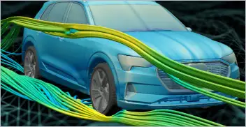
From geometry preparation to AI-assisted analysis, integrated CFD workflows…
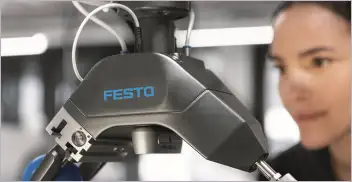
Software-based GripperAI manages mixed picking through basic geometry
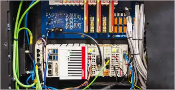
Safety, communication and motion control components enable smooth operation

North America’s largest robotics and automation event winds down